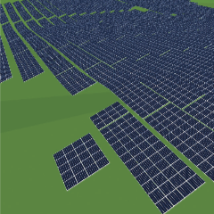
Ground mounted PV systems in open spaces are increasingly being built on hilly terrain and not only on flat surfaces such as farmlands or conversion areas. An essential uncertainty is to accurately calculate the correct position and length of the posts. PES was keen to hear about Levasoft’s solution to this problem.
Integral software solution of the calculation of statics and project design for ground mounted PV systems
This is critical, because of saving costs on material and ramming. For us, this meant the further development of Solar.Pro.Tools program logic in order to be able to design modules or elevation systems in the terrain and to statically calculate these with algorithms, which smooth the distribution of posts via linear programming.
Challenge
The challenge to us was how the so called PV system tables could be positioned in the terrain, without creating lots of individual plants. Through iterative automated testing, we applied variances into the algorithms, which, within parameters, merge adjacent modules into tables, without creating new tables. Another task was, if we could still calculate the distribution of posts in this new, three-dimensional system and if possible, would it be still performant enough to calculate even larger plants?
This is the most complex problem with ground mounted PV systems. Despite an extensive range of wind areas, irregular terrain, various components of steel and aluminium, a homogeneous distribution of the poles, which carry the assembled system, needs to be calculated in the end. So, we expanded our concept with the ‘terrain’ component, which led to terrible results.
As the loads, of snow and wind, on the modules are distributed even more irregularly to the terrain via the frame system, it is very difficult to find a homogeneous design of the posts. Therefore, for variances in the algorithms, the deflection moments of the rails were analysed, and the strengths of the rails improved. The results have improved, but in some cases, they still lead to problematic interpretations. For this reason, we began to develop a new concept in order to simulate the calculation of the rails and the positioning of the posts via a finite element method.
Another task was to read the terrain using three-dimensional data and basically model it. For this purpose, algorithms were developed to read out so called point clouds or contour lines in CAD files or as defined in the tachymeter data, and to be able to map them inside the data structure. Based on terrain data and the definition, the module layout of where to build the plant is generated. Reference points are created automatically, which are then used later as on site starting points for the installers.