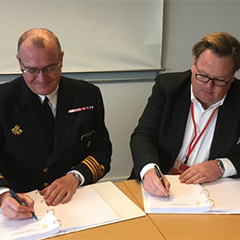
Tuco Marine Group signs contract with DALO for two hydrographic survey vessels for operations in Danish inland waters.
A lot has happened since hydrographic surveys were conducted using lead lines that were lowered into the water until they hit the bottom. Today there are technologies available such as sonar and lidar that utilize sound or laser impulses respectively to create precise data which is then post-processed into actionable information and images of the seabed and its contours.
Tuco Marine Group has just signed a contract with DALO (The Danish Defence Acquisition and Logistics Organization) on two bespoke hydrographic survey boats that are to replace two obsolete survey vessels. The new boats are based on Tuco’s ProZero concept and have been designed to allow full use of the latest technology for hydrographic surveys.
The boats are designed to accommodate two hydrography specialists in addition to a dedicated helmsman. The hull has been specially adapted to address two challenges that are hard to solve at once: on the one hand the low draft capacity to operate in uncharted shallow waters where you face the risk of running aground and on the other hand antiroll and directional stability. The boats are equipped with jet drives and stabilizing features which make them highly agile and seaworthy. The design enables more efficient surveys under changing weather conditions and the hydrodynamic profile of the hull reduces turbulence and vibration so as not to interfere with the highly sensitive measuring equipment. The efficient design enables extensive operations over large areas.
The advanced sonar equipment is fixed under the boat and recessed into the structure to protect it against adverse conditions. High performance sensors and processors that are able to capture and process the signals as well as correcting and managing multiform data streams constantly produce and store high quality information that accurately represent the actual sea floor.

